The stone foundation of the houses in karum generally came as far as the
floor and supported walls made of adobe The upper walls were strongly built with
timber posts in the adobe walss of the rooms and horizontal timber beams above the stone
foundation indicating that they suppoerted a second storey. The floors are of beaten
earth, dark in color and oily in appearance.
|
The primary importance of Kültepe, in relation to history, is its being
the site of the earliest Anatolian written documents. The first appearance of Anatolia
into the light of history was in this era and through these documents. The clay tablets
were written in an ancient Assyrian dialect, using the cuneiform script. At the
beginning of the 2nd millennium BC, Anatolia enjoyed one of the most prosperous periods in
its history. The Assrians who inhabited Northern Mesopotamia, established great trading
outposts in Anatolia which they called Karums. Among these, the Karum of Kanesh was the
controlling centre to which all the other Karums were subordinate; in its turn, it was
directly connected to Assur. Using routes through Assur-Diyarbakır-Malatya-Kayseri, or
Assur-Urfa-Adana - the pass of Külek, Assyrian merchants imported tin, garments, and
cloth by means of caravans of 200-250 donkeys, and sold their goods to the native people,
in exchange for good and silver. |
Karum, the settlement of the Assyrian merchants.
 The Karum occupies four building levels, the last of which occurs in two
phases. In Level IV, which is the earliest and which is built on virgin soil, and in the
subsequent Level lll, writing is unknown. The most advanced phase, called the Assyrian
Trading Colonies Age in Anatolian history, is represented by Level II, and dates
approximately from 1950 to 1850 BC At this level, quarters were formed by a close
arrangement of regular buildings around squares and streets. The house have stone
foundations and mud-brick walls; wood was also used extensively as a building material.
The houses are spacious in their accommodation. The majority have 3-4 or 5-6 rooms and a
wide hall. The Karum occupies four building levels, the last of which occurs in two
phases. In Level IV, which is the earliest and which is built on virgin soil, and in the
subsequent Level lll, writing is unknown. The most advanced phase, called the Assyrian
Trading Colonies Age in Anatolian history, is represented by Level II, and dates
approximately from 1950 to 1850 BC At this level, quarters were formed by a close
arrangement of regular buildings around squares and streets. The house have stone
foundations and mud-brick walls; wood was also used extensively as a building material.
The houses are spacious in their accommodation. The majority have 3-4 or 5-6 rooms and a
wide hall.
 The archive-rooms are separated from the living rooms, which, in their
turn, are distinct from the bedrooms, the kitchens and the store rooms. By means of the
archives, it is possible for us to learn the owners’ identities, and to establish their
Assyrian or native origins. The great fire which destroyed the city barely allowed the
inhabitants to escape with their lives, and to save what they had on their persons; all
kinds of household utensils, marvelously evolved pottery, animal-shaped drinking cups and
statuettes were abandoned, waiting for future discovery. The houses of this level, which
had one or two storeys, were uncovered in good condition; this has considerably simplified
the task of reconstructing the site. So far, 15.000 tablets and envelopes have been
discovered at this level, which represents the most brilliant phase of the Assyrian
Trading Colonies. As the dead were buried in their own houses, burial gifts were
discovered as well. Rich with gifts, stone cist-graves are found in all quarters of the
city. The archive-rooms are separated from the living rooms, which, in their
turn, are distinct from the bedrooms, the kitchens and the store rooms. By means of the
archives, it is possible for us to learn the owners’ identities, and to establish their
Assyrian or native origins. The great fire which destroyed the city barely allowed the
inhabitants to escape with their lives, and to save what they had on their persons; all
kinds of household utensils, marvelously evolved pottery, animal-shaped drinking cups and
statuettes were abandoned, waiting for future discovery. The houses of this level, which
had one or two storeys, were uncovered in good condition; this has considerably simplified
the task of reconstructing the site. So far, 15.000 tablets and envelopes have been
discovered at this level, which represents the most brilliant phase of the Assyrian
Trading Colonies. As the dead were buried in their own houses, burial gifts were
discovered as well. Rich with gifts, stone cist-graves are found in all quarters of the
city.
 The reason for the burning of the city and the identity of its destroyers
are not known. The place remained deserted for 40-50 years after the destruction of Level
II, when finally, in approximately 1800 BC people of the same origin built city Ib upon
the debris. The new city is contemporary built very close together. The plans are more
spacious and the number of rooms has been increased. The number of houses with wide rooms
and with large store-rooms is considerable. In spite of the fact that there are few
written documents, this level enjoyed at least as much prosperity as Level ll. It was
likewise destroyed in a great fire. However, as the use of wood as a building material was
less common here than stone, the destructive force of the fire was diminished. On both
levels, the Karum was surrounded by a city wall, with a diameter of no less than 2000-2500
m. After its second destruction, the importance of the Karum of Kanesh entirely waned; it
was abandoned as an area of inhabitation and was left in ruins. With the end of this
settlement, the Assyrian language and cuneiform script ceased to be used in Anatolia. The reason for the burning of the city and the identity of its destroyers
are not known. The place remained deserted for 40-50 years after the destruction of Level
II, when finally, in approximately 1800 BC people of the same origin built city Ib upon
the debris. The new city is contemporary built very close together. The plans are more
spacious and the number of rooms has been increased. The number of houses with wide rooms
and with large store-rooms is considerable. In spite of the fact that there are few
written documents, this level enjoyed at least as much prosperity as Level ll. It was
likewise destroyed in a great fire. However, as the use of wood as a building material was
less common here than stone, the destructive force of the fire was diminished. On both
levels, the Karum was surrounded by a city wall, with a diameter of no less than 2000-2500
m. After its second destruction, the importance of the Karum of Kanesh entirely waned; it
was abandoned as an area of inhabitation and was left in ruins. With the end of this
settlement, the Assyrian language and cuneiform script ceased to be used in Anatolia.
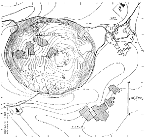
The houses of Levels II and Ib can be observed together at Excavation area No. 1,
situated at the centre the Karum; in Excavation area No. 2, Levels Ib,II,III, and IV are
all represented together, while area No. 3 covers the houses, roads and squares of Level
ll exclusively.
During the Age of the Assyrian Trading Colonies, the Anatolian people not only mastered
the foremost invention of human history, namely writing, but also established connections
with the Mesopotamian civilization, which constitutes the basis of all ancient
civilazations. In this manner the indigenous people of Anatolia found a means to develop
their way of thinking, their philosophy of life and their art. Through contact with and
assimilation of ancient Mesopotamian art, a new Anatolian style came into being, which is
called Hittite Art by archaeologists. After the Karum area fell into decay for
obscure historical reasons, habitation of the mound continued.
The settlement of the autochthonous people
The mound of Kültepe was inhabited from the 14th millennium BC on, that is from the
Chalcolithic Age, to the end of the Roman period. With its spacious buildings, its large
alabaster idols, fashioned into a single body and many heads, its statuettes, either
clothed or naked, and its painted pottery, Kültepe was one of the most important sites of
Anatolia in the Early Bronze Age, especially in the late phase (2500-2000 BC). At Kanesh,
which was the capital of the Kingdom of Kanesh during the Age of Assyrian Trading Colonies
princes lived on the mound, within the city walls in great palaces which have been
unearthed during excavations. Still intact, the palaces form a great complex, possessing
wide courts faced with stone, large halls, long corridors and suites used by the princes,
and for the administrative functions of the kingdom.
After the Assyrian Trading Age, Kültepe lost much of its political and economic
importance and was unable to re-achieve the status of a great centre during the Old
Hittite or Hittite Imperial periods.
During the Neo-Hittite Age, from 1000 BC, Kültepe was one of the foremost cities of
the country called the Kingdom of Tabal by the Assyrians. However, the city was
considerably destroyed during the Hellenistic and Roman ages; consequently it has not been
possible to find traces of palaces, decorated with sculptured slabs, the existence of
which we know. In spite of this, sculpture, painted pottery and seals have been discovered
in sufficient abundance to indicate the Hellenistic and Roman Periods, Kültepe was one of
the one of the most important cities of Cappadocia despite its closeness to Kayseri.
The first excavation of the Kültepe mound was started by the French explorer, Ernst
Chantre, in the years 1893-1894. He was succeeded in 1906 by H. Winckler,
the discoverer of the Boğazköy archives. B. Hrozny, who made a great
contribution to archaeological knowledge by decihering Hittite cuneiform script, performed
the first excavations at Karum in 1925. Unfortunately, the excavations were not carried
out systematically, as their sole objective was to discover tablets, and thus caused a
great deal of destruction. The first systematic excavations of the mound and of the Karum
and area were begun under the auspices of the Turkish Historical Association and the
General Directorate of Antiquities and Museums in 1948, and have since been regularly
continued.
- Further documents:
- Contract concerning the Sale of a Slave Woman
Marriage Contract
-
- Source:
- Ancient Civilizations and Ruins of Turkey
Ekrem Akurgal,
Istanbul 1973
|
 finest works of art exhibited in the Ankara Museum. The following
description has been prepared by Professor Özgüç.
finest works of art exhibited in the Ankara Museum. The following
description has been prepared by Professor Özgüç. The Assyrians did not exercise power or
influence of a political or administrative nature in Anatolia. To the local princes who
ruled Anatolia at that period, the merchants were obliged to pay taxes, in return for a
guarantee of safety. The majority of the written documents are commercial, economic and
legal in nature; in addition, there are some historical and literary texts. The envelopes
in which these letters, contracts or deeds were placed, bore cylindrical seal impressions,
belonging to such people involved in these business transactions as the lender, the
borrower and the witnesses. In this manner, the habit of using cylindrical seals, widely
practiced in Mesopotamia, where they constituted the native craftsmen to create very
evolved examples of this branch of art, and to develop a native style.
The Assyrians did not exercise power or
influence of a political or administrative nature in Anatolia. To the local princes who
ruled Anatolia at that period, the merchants were obliged to pay taxes, in return for a
guarantee of safety. The majority of the written documents are commercial, economic and
legal in nature; in addition, there are some historical and literary texts. The envelopes
in which these letters, contracts or deeds were placed, bore cylindrical seal impressions,
belonging to such people involved in these business transactions as the lender, the
borrower and the witnesses. In this manner, the habit of using cylindrical seals, widely
practiced in Mesopotamia, where they constituted the native craftsmen to create very
evolved examples of this branch of art, and to develop a native style.