|
|
|
|
|
|
 Located
on the upper Tigris basin, at the junction of historical trade routes connecting Anatolia
to Iran and Mesopotamia, Diyarbakır, surrounded by walls, has been an important
settlement for many centuries. Located
on the upper Tigris basin, at the junction of historical trade routes connecting Anatolia
to Iran and Mesopotamia, Diyarbakır, surrounded by walls, has been an important
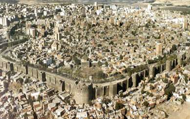
settlement for many centuries.Starting from the earliest times, the city was ruled by the Hurri-Mithani, Hittites and Assyrians. It was once the capital city of the Arami Bit-Zamani Kingdom. It was later occupied or ruled by the Meds, Pers, Macedonians, Selevkos, Parts, Romans, the Ilkhanide and the Akkoyunlu. It is referred to as Amidi, Amid, Amido or Amida in different sources. In Islamic-Arabic sources it is cited as Diyar-i Berk. In the republican era it is started to be known as Diyarbakır deriving from the copper ore existing in the area. The province has a territory of 15.355 square kilometres. Dry farming and fallow are practised over most of its culture land. The population is 1.282.678, living in 13 districts (including the central town) and 734 villages. Its administrative districts are Bismil, Cermik, Cinar, Cungus, Dicle, Edil, Ergani, Hani, Hazro, Kocaköy, Kulp, Lice and Silvan. Diyarbakır is the second most populated city in Southeastern Anatolia. It is made up of "old" and "new" sections. The "old" section is surrounded by walls. Having four main gates, these walls are the grandest and the most solid of all such structures existing in Anatolia. The important historical structures remain in this part of the city. The "new" section out of the walls developed under a plan in the Republican period. It gives a sharp contrast to the old section with its orderly avenues, independent dwellings, parks, official buildings and big hotels. The most important stream in the province is the Tigris. Diyarbakır is located on a transition zone connecting the mountainous northern areas and the plains of Mesopotamia. It is presently at the centre of the highway network connecting other important settlements of the region such as Elazığ, Mardin, Şanlıurfa and Bitlis. The railway reached the city centre in 1935 and was later extended to Kurtalan out of the territory of the province. Diyarbakır has air connections to the big city centres of Turkey. Despite its present status of dependency on crop farming and stock breeding, Diyarbakır has a considerable potential for other investment ventures and presently it is the second industrial centre of the region after Gaziantep. It has an organised site for small enterprises. Diyarbakır is one of the provinces accorded priority in development. The province is now moving to concentrate on feed and meat production, which increased capacity for marketing, while maintaining its traditional branches of industry. Diyarbakır Fortress and WallsThe most famous structure which witness to the rich historical heritage of Diyarbakır is its fortress. This fortress located on a solid rock called "Fis" 100 metres high from the Tigris is believed to be built by the Hurri. The citadel has a domed basilica (a Nasturian Church from the 6th century), a mosque, Sahabeler tomb, an Artuklu Palace and some old official buildings. The walls are the longest in the world after the Chinese Wall. One can trace back 12 different civilisations from inscriptions on these massive and solid walls. The original builder is not known. The walls are extended and consolidated by the Roman Emperor Constantinus in 349 AD. The four main gates open to four main directions. Having a length of 5 kilometres, the walls are 12 metres high, 3-5 metres wide and have 82 watchtowers. Cahit Sitki Tarancı museumThe house where Cahit Sitki Tarancı, one of the most celebrated poets of the Republican period was born was turned into a museum in 1973. The museum exhibits the photographs and personal articles of the poet as well as some ethnographic pieces obtained from the area. The house bears the characteristic features of local architecture. Deliler InnIt was built by Husrev Paşa in 1527 and also known by his name. It is a two part structure, a two storey main part and a stable. The local people call it deliler (guides) since guides who took pilgrims from various locations to Mecca each year used to gather here. The remains existing just across the inn are also attributed to pilgrims. The inn was restored and turned into a modern hotel with a capacity of 120 beds. Malabadi BridgeThe bridge is near Silvan, a district of Diyarbakır, on Diyarbakır-Batman provincial border. It is a magnificent Artuklu piece which witnessed so many events. It has the widest arch width among all arch bridges in the world. It connects two banks of the stream not on a straight but broken line. Evliya Çelebi, a well known Ottoman traveller says the following about the bridge: The bridge has iron gates on both sides. There are hostels in these gates, to the right and to the left, and also under the arch. While some chat, others fish by throwing their nets down to the Batman Brook. The inscription on the bridge gives the date of construction as 1147-1148. The inscription also reveals that the bridge was built by Timurtas, the ruler of the Artuklu in Mardin. Grand Mosque in DiyarbakırIt is one of the oldest mosques in Turkey. It is known that the Church of Saint Thomas was gradually converted into a mosque. It is a grand and impressive structure, built of cut stone over an area of 80 x 80 metres. The minaret behind the mosque is rectangular. Its fountain (1849), carved marbles and niche are all important artworks. The walls of the mosque are also ornamented with reliefs and carvings. The minaret and the gate bear 20 inscriptions dating back to various periods in history. The tombs in the yard was destroyed by the Persian King Ismail in 1507. Handicrafts in DiyarbakırJewellery, silk processing, coppersmith works, pottery, leather works, felt making, textiles, embroidery and carpet making are the leading handicrafts. Among them, jewellery is still important. Mat bracelets, coriander, necklaces and silver ornamented wooden shoes are the special works of the province. Sericulture is practised at the city centre and in the districts of Kulp, Silvan and Lice. However, silk production is in decline. Textiles which lived its golden age in the 40s now survive only in small workshops.
|
| |
Our Hotel | Turkey | Cappadocia | Daily Tours | Views | Guestbook | Request Form | Home |