|
The Kızılırmak is the artery which gives life to the
Anatolian steppe: to flowers, insects, people and the soil. With countless tributaries and
a length of 1355 kilometres the Kızılırmak is Turkey’s longest river. It rises on
Mount Kızıldağ in the northeast of the central Anatolian region and is soon swelled by
a series of streams close to itself in size in its home province of Sivas. By the time it
crosses into the province of Kayseri it is already several times its original volume, and
continues to swallow up tributaries along its westward route past towns and cities. |
At Avanos the river swerves to
the northwest to pour into the Black Sea at Bafra. The Kızılırmak delta, with its
numerous lakes, large and small, is one of Turkey’s most important areas for
birdlife.The Turkish name the Red River derives from the colour of the water,
whereas in antiquity the Kızılırmak was known as the Halys, a name meaning ‘salty
river’. This river valley was home to diverse civilisations over Turkey’s long
history, and many traces of them are still to be seen today, such as rock tombs, castles,
bridges and settlements.
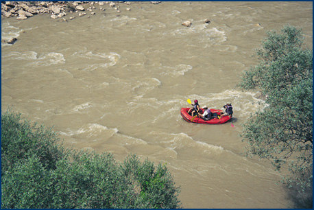
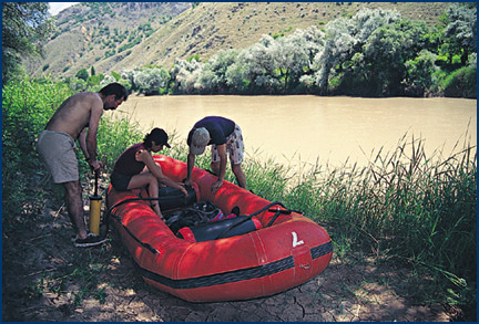
Five of us decided to follow the course of the Kızılırmak to see this ancient heritage
at close quarters along its valley created over thousands of years. We were to travel by
inflatable dinghy, and chose the month of June when the river water is at its clearest.
The first stage of our journey was that part of the river in the province of Kayseri,
where roads along its valley are virtually nonexistent and nature barely touched by man. |
This stretch of the river, approximately eighty kilometres in length, flows past no large
towns.Since differences in altitude are negligible in this part of Kayseri the river is
generally sluggish, sometimes appearing as still as a lake. But this tranquility turned
out to be deceptive, since on occasions we suddenly found ourselves racing along and being
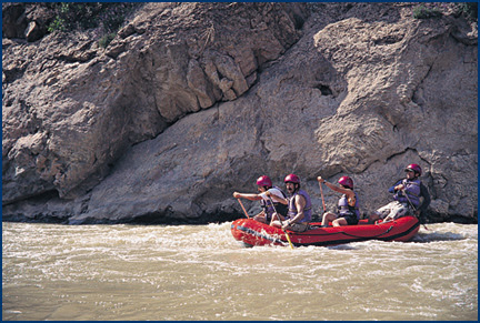
swept over rapids as the river suddenly surged downwards. Our chosen method of travel
meant that we had to be prepared for accidental tumbles overboard and struggling to stay
afloat in the rushing water. |
|
|
The Kızılırmak valley frequently alters in
appearance with the changing geological structure of the terrain. Before reaching Felahiye
Bridge the river flows through high hills and occasionally rocky gorges, but beyond the
bridge this scenery makes way for volcanic rock. The river is here within range of the
eruptions of Mount Erciyes, the volcano which created this unique landscape. The colour of
the basalt rock constantly varies, particularly in the afternoon light, to spectacular
effect. The red hue of the river water is turned an even deeper crimson by the reflections
of the rock on the water. |
This remote and rocky landscape is a haunt of large
numbers of birds of many diverse species, one that we frequently spotted all along the
river being the Egyptian vulture.The red waters of the river flow amidst white willows
with olive green foliage, and sometimes reeds and willows together. We saw anglers in the
welcome shade of the willows fishing for sheatfishes. Some were fishing with rods but
others with nets, despite this being illegal. The great number of fishermen was an
indicator of the teeming wildlife for which the river and its banks are a habitat.
Colourful dragonflies were plentiful all along the river. |
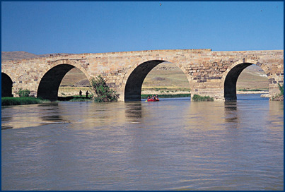
| There are many historic bridges over the Kızılırmak, and during our
journey we passed a halfruined bridge near Çukur, and the Çokgöz and Tekgöz bridges.
The latter was built in 1202 during the reign of Rükneddin Süleyman Şah, son of the
Seljuk ruler Sultan İzzeddin Kılıç Arslan II. Çokgöz is another Seljuk bridge which
is still in use. It has no less than fifteen arches, hence the name Çokgöz (Many
Arched). Past this bridge the river makes a sharp turn alongside cliffs, marking the start
of a stretch of spectacular beauty. Near Çukur, on a high rock rising from the river is
the awesome Zırha Castle, perched like an eaglsdm eyrie. Past Hırkaköy is a great
timber bridge nearly 150 metres in length and broad enough for cars to cross
which harmonises perfectly with the river, enhancing its beauty. The Kızılırmak
brings life to all the lands its passes through. Wherever the valley floor widens out even
a little, farmers take advantage of the fertile soil. Where the valley widens into plains
several kilometres broad there are villages. If not for the Kızılırmak this region
would be arid steppe land unsuited to agriculture. As we approached each village the sound
of motorised water pumps could be heard. The farmers raise water from the river to
irrigate their fields, relying mainly on water pumps, but where these are inadequate
constructing huge water wheels like the one which we saw at the village of Kuşcu.
The Kızılırmak reshapes the dry and harsh conditions of the central Turkish steppe,
creating an environment along its course on which many living things depend. This was
brought home to the five of us during our boat journey downriver.
|
- Kaynak:
- Skylife 08/2000,
By Ali Ihsan GÖKÇEN
|
|