Mountaineering in Turkey
A glance at a topographical map of Turkey reveals that
this is a country of mountains. Rising from all four directions, mountains encircle the
peninsula of Anatolia. A part of the Alpine-Himalayan Mountain range, Turkey has
mountainous regions with different geological formations.The North Anatolian range skirts
the Mediterranean shore.
Turkey's magnificient mountains and forests are mostly undeveloped, existing as
wonderful natural preserves for an extraordinary variety of wild life, flora and fauna.
Two of Turkey's most famous peaks are volcanos, both inactive, Mt.
Erciyes in Kayseri in Central Anatolia (3917 m) and Mt. Ağri;
(Mt. Ararat 5137 m) in the east. Other mountain ranges are the Rize Kaçkar
(3932 m) in the eastern Black Sea region, Niğde Aladağlar;
(3756 m) in the central Taurus range and the Cilo and Sat mountains
(4136 m) near Hakkari in the eastern Taurus.
The mountainous nature of the country has inflounced its cultural evolution. For
centuries, nomads and semi-nomadic peoples have moved yearly to the fresh pastures of the
higher elevations in the summer. These alpine medows, called yayla, house nomadic
people whose traditional culture is still preserved.
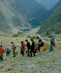
For climbers and those interested in the geography of mountains, Turkey offers a wealth
of exploration. Glaciers, volcanos, and peculiar geological formations such as karst prove
irresistable to researchers and students of the geology. The challenging terrain offers
opportunities to aficionados of outdoor sports, who find the most interesting experiences
on the mountains of eastern, central and southern Turkey. A list of resources to aid an
expedition, is found in the rest of this text.
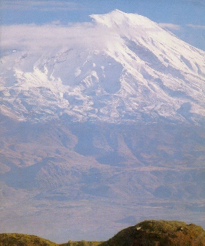
THE GREAT MOUNT OF AĞRI (ARARAT) - 5137 m.
Rising at the borders of Turkey and Iran, Mount Ağrı, an inactive volcano capped year
round with ice and snow, rises to 5137 meters. The Old Testament records that it was on
this mountain that Noah's Ark came to rest after the great flood. Southwest of the
mountain, the Little Mount Ağrı (Ararat) reaches up to 3896 meters; the Serdarbulak lava
plateau (2600 m) streches out between the two pinnacles. Climbing the spectacular Ağrı
is a challenging and rewarding experience. (View map.)
 In the summer, the weather in the area and on Mount Ağrı is sunny, warm and
dry. However, in the winter and spring, cold and harsh conditions prevail, and mountain
climbers occasionally face blizzards and turbulent weather. July, August, and September
are the months when most world mountain climbers come to the area. Climbing up Ağrı is
most enjoyable during this period. However, despite the usual sunny and clear weather at
that time of year, high altitude mountain weather swirls around above 3000 meters. The
southern side of the mountain offers the easiest and safest climb to the summit. With this
route one has access to the best route communication and transportation facilities and it
is safe. It is not recommended to climb Mount Ağrı alone and without a guide. In the summer, the weather in the area and on Mount Ağrı is sunny, warm and
dry. However, in the winter and spring, cold and harsh conditions prevail, and mountain
climbers occasionally face blizzards and turbulent weather. July, August, and September
are the months when most world mountain climbers come to the area. Climbing up Ağrı is
most enjoyable during this period. However, despite the usual sunny and clear weather at
that time of year, high altitude mountain weather swirls around above 3000 meters. The
southern side of the mountain offers the easiest and safest climb to the summit. With this
route one has access to the best route communication and transportation facilities and it
is safe. It is not recommended to climb Mount Ağrı alone and without a guide.
GETTING THERE
The Trabzon-Erzurum-Iran International Transit Highway, an asphalt road skirts the
western and southern flanks of Ağrı before leading into Iran. Doğubeyazit, 270 km from
Erzurum and nearby Iğdir, the two closest towns to the mountain, are located on this
route. Planes, trains, and buses connect Erzurum with Ankara.
REGIONAL ATTRACTIONS
The area surrounding Ağrı has retained its natural beauty. The local population still
engages in a traditional life styles. In the summer months the villagers move to the
yayla, the summer pastures, to find fresh grazing for their herds of sheep, goats, cattle
and horses. Women continue to weave carpets and kilims in time-honored designs; Village of
Ortulu is particularly renowned as a center of beautiful handicrafts. Other nearby tourist
attractions include the Ishakpasha Palace, a fabulous 18th century castle of a local
potentate, and the meteor hole near the Iranian border.
THE CILO-SAT MOUNTAIN RANGE (4136 m.)
The Cilo-Sat mountains, within the southeastern Hakkari province are the eastern
extension of the Toros (Taurus) mountain chain which stretches from west to east along
Turkey's southern boundaries. The mountain range forms the western section of the
Himalayan mountain belt. At 4136 meters, the Uludoruk (Reşko) summit is the highest in
the Cilo mountains; Catalkaya (Samdi), which rises to 3794 meters crowns the Sat
mountains. (View map.)
Resembling the Alps both in general appereance and glacier topography, the Cilo-Sat
mountains are the areas in Turkey most affected by glaciers. The high altitudes of the
mountains testify to the effects of glacial formation and water erosion. Of the ten
differently shaped glaciers, the largest, Izbirak, measures five kilometres in length,
500-600 meters in width. It reaches up to 100 meters in depth.
A wide arid expanse stretches across the southern base of the mountain range. The
highlands, in contrast, receive plentiful precipitation during the winter months. In
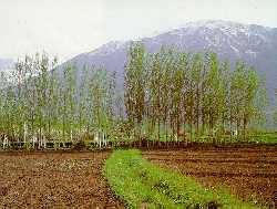
between crests and summits, fertile green valleys dotted with rural settlements, enjoy a
temperate climate that makes them ideal for wine and fruit Ağrıculture.
Above the low valleys, alpine meadows blanket the mountain slopes at altitudes between
2000 and 3100 meters. Herds of domestic animals, the raising of which makes up the primary
economic activityof the region, graze on these pastures.
TRIPS AND CLIMBS
Arduous and elevated summits, high glaciers, glacial rivers and fast moving streams
combine to make the Cilo-Sat mountains both a fascinating geographic and geological site
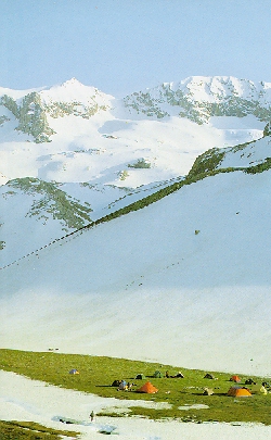
of worldwide importance and a national park of spectacular beauty. The best time for
summer excursions is during June, July, August and September. For winter climbing February
and March are the most suitable months.
GETTING THERE
To reach the Cilo-Sat mountains, travel to Van from Ankara by road, rail, or air and
then follow the 245 km long highway to Hakkari. Serpil village offers one route for an
ascent of Uludoruk; another route is Dezköy.
REGIONAL ATTRACTIONS
A vast plateau, yayla culture has evolved on the Cilo and Sat mountains, and the summer
migration of the colorfully clad local population to the high grazing pastures is a
memorable event. Mountain glaciers and swiftly running rivers alive with fish and
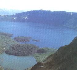
beautiful glacier lakes are a few of the area's natural wonders.
THE KAÇKAR MOUNTAINS (3932 m.)
 In the rainy and lush landscapes of northeastern Turkey, the Kaçkar
mountains form the northern section of the Anatolian mountain chain. The Kaçkar Kavron
summit, at an altitude of 3932 meters, is the highest point in the range. Extensive
glacier and water erosion have given these mountains their craggy, rugged look, and they
are known for the complexity and power of the streams and rivers which rush down to the
lower altitudes. In fact, this range is the third most important glacial region in Turkey
following the Ağrı (Ararat) and Cilo-Sat mountains. The geological and mountaineering
aspects of the Kaçkars contribute to their importance in Turkey's economy and tourism. In the rainy and lush landscapes of northeastern Turkey, the Kaçkar
mountains form the northern section of the Anatolian mountain chain. The Kaçkar Kavron
summit, at an altitude of 3932 meters, is the highest point in the range. Extensive
glacier and water erosion have given these mountains their craggy, rugged look, and they
are known for the complexity and power of the streams and rivers which rush down to the
lower altitudes. In fact, this range is the third most important glacial region in Turkey
following the Ağrı (Ararat) and Cilo-Sat mountains. The geological and mountaineering
aspects of the Kaçkars contribute to their importance in Turkey's economy and tourism.
The region enjoys an almost sub-tropical climate of temperate yet rainy weather with an
average temperature of 14º C. The lowest temperature, 7º C., fall in the month of
January while August sees the hottest days reaching a maximum recorded temperature of
22.6º C.
The Kaçkars rise in between the shores of the Black Sea to the north (see map) and the River Coruh valley to the south (see map). On the northern flank, a good variety of
vegetation flourishes in the rainy climate. Up to 500 meters above sea level, tea
plantations and citrus orchards cover the hillsides. Chesnut, hornbeam, beech and other
large-leafed trees forest the slopes to 750 meters. Between 750-1500 meters of elevation,
pines mix in with the large-leafed trees forest the slopes to 750 meters. Between 750-1500
meters of elevation, pines mix in with the large leafed trees until gradually they remain
the only species of tree from 1500-2000 meters. Alpine meadows and other grassy vegetation
covers the ground above 2100 meters. On the southern faces of the Kaçkars, which receive
strong sunshine and less precipitation, the agriculture is based on the cultivation of
fruits and vines. As on the north side in the higher elevations, meadows of wild flowers
and grass blanket the slopes up to 2300 meters.
TRIPS AND CLIMBS
The Altiparmak, Kavron, Varsamba mountains are the principal peaks of the Kaçkars.
Both the north and south faces of the Altiparmak and Kavron can be scaled but Varsamba
should only be attemted from the north face. It is imperative to use a local guide when
climbing the Kaçkars.
THE TOROS (TAURUS) MOUNTAINS
The Toros Mountains are the western most branch of the great mountain chain that
stretches across all of Asia - the Himalayan mountain belt. The Turkish section of this
massive mountain range follows the southern border of Anatolia and it is made up of four
major sections, the Western, Central, Southern and Southeastern Toros ranges. The highest
peaks rises out of the Central and Southeastern branches, a stretch of mountains which are
rugged, magnificent and arduous to climb.
THE TOROS ALADAĞLAR MOUNTAINS
Forming part of the Central Toros range, the Aladağlar range runs from the southwest
to the northeast for approximately 50 kilometers. It is between 25 and 30 kilometers wide
and boasts the region's highest peak, Demirkazık which stretches to 3756 meters. Other
high summits include Kızılkaya in the center (3725 m), a peak that reaches 3688 meters
in the south and Mount Vayvay in the East (3565m). The long range is situated in the
provinces of Niğde and Adana and
rises between Lake Ecemis and the Zamantı river (maps).
EMLI VALLEY - ALADAĞLAR NIĞDE
The geological formation of the area is responsible for the interestingrock formations
and waterfalls. The erosion of limestone has created a fascinating karstic topography and
hydrography, especially in the Yedigöller valley, where karstic underground rivers and
caverns collect the surface water. Both the Mediterranean and Anatolian weather systems
influence the climate of the Aladağlar bringing warm summers and cool winters to the
mountains.
 TRIPS AND CLIMBS TRIPS AND CLIMBS
The best season to climb the mountains is during June, July and August when the alpine
meadows of higher elevations are rich in vegetation.
Researchers and mountaineers ascending the Aladağlar usually begin their climb from
either Camardi or Cukurbag villages. Those attempting to climb the Demirkazık summit
depart from Demirkazık village. Both of these village lie 65 km from Niğde and can be
reached by an asphalt road.
REGIONAL ATTRACTIONS
The plateau, yayla of the Toros Aladağ are the summer homes of entire villages and the
summer grazing of herds of animals. Be sure to see the gathering in of all the animals for
milking. Traditionally women of these encampment have produced some of Turkey's most
beautiful carpets and kilims, and it is often possible to see a carpet still in progress.
MOUNT ERCIYES (3917 M.)
 One of Turkey's most important mountaineering and winter sports centers, Mount Erciyes, rises from the south of the Kayseri
valley. The Sultan Sazlığı marshes lie to its west and
to the south falls the Develi valley. Its summit always covered with snow and ice, Mt.
Erciyes ranks as central Anatolia's tallest volcano. One of Turkey's most important mountaineering and winter sports centers, Mount Erciyes, rises from the south of the Kayseri
valley. The Sultan Sazlığı marshes lie to its west and
to the south falls the Develi valley. Its summit always covered with snow and ice, Mt.
Erciyes ranks as central Anatolia's tallest volcano.
Approximately 18 kilometers in diameter and covering an area of 1000 square kilometers,
the mountain's stratification and geology make it a fascinating geographical formation.
The region's climate, influenced by that of the Anatolian plateau is typical steppe.
Winter brings considerable snowfall to higher elevations. The northern side of the
mountain enjoys a more temperate climate encouraging the cultivation of vast areas of vine
and fruit orchards between 1100 and 1600 meters. Above that altitude, expanses of meadows
stretch far into the distance. The higher elevations display typical alpine vegetation.
Herds of animals graze year round on the east, north and west slopes of the mountain.
TRIPS AND CLIMBS
Mountaineers attempt Mt. Erciyes either on the northwestern flank or from the south and
find the best climbing in June, July, August and September.
REGIONAL ATTRACTIONS 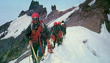
Tourists visiting the area should also see the fantastic rock formations, underground
cities and fabulous frescoes in rock carved churches in neighbouring Cappadocia. The
Sultan Marshes, a habitat for many different species of birds, has been fortunately
designated a national park and wildlife preserve.
MOUNT NEMRUT (3050 m.)
In fact, Turkey can boast of two peaks called Nemrut. The one near Adıyaman in the southeast is primarily of historical and
archaeological interest, home for over 2000 years to the colossal stone heads of King
Antiochus I and classical dieties. The other mount Nemrut in in eastern Anatolia, the more
interesting of the two peaks, is well-known for its geological formation and for
mountaineering purposes.
 An
inactive volcano, Mt. Nemrut nearby Tatvan ascends to 3050 m. It is located within the
process of Bitlis, rising from the southwestern shore of Lake Van, and entering the
district of Ahlat to the north. Mt. Nemrut is the most southern and youngest of the chain
of volcanos in the eastern Anatolia. A strato-type volcano, Mt. Nemrut began erupting
during the fourth geological era and continued to be active untill 1441 A.D. As a result
of the volcanic eruptions of Mt. Nemrut, the single Van - Muş river basin was divided
into two separate basins. An
inactive volcano, Mt. Nemrut nearby Tatvan ascends to 3050 m. It is located within the
process of Bitlis, rising from the southwestern shore of Lake Van, and entering the
district of Ahlat to the north. Mt. Nemrut is the most southern and youngest of the chain
of volcanos in the eastern Anatolia. A strato-type volcano, Mt. Nemrut began erupting
during the fourth geological era and continued to be active untill 1441 A.D. As a result
of the volcanic eruptions of Mt. Nemrut, the single Van - Muş river basin was divided
into two separate basins.
TRIPS AND CLIMBS
Treks up Mt. Nemrut begin on the mountain's southeastern flank at Tatvan. Climbers
reach the south or southeastern side of the crater after an easy hike for 4-5 hours. Those
who reach this point have the rare chance to see the wondrous crater of this inactive
volcano. For those who find the climb to the crater too strenuous, four-wheel drive
vehicles can reach the summit from either Ahlat or Tatvan.
Mt. Nemrut is bare of vegetation, except in the south which has oak groves and birch
trees. Summer (June - September) is the best season for expeditions in Mt. Nemrut. Hikers
who climb to the crater and summit from the southeast or eastern face of the mountain are
rewarded with wonderful views of Lake Van.
MOUNT SÜPHAN (4058 m.)
Mount Süphan, a magnificent dormant vocano rises from the north-west shores of Lake
Van.
Throughout the winter, snow falls on Süphan reaching three to four meters. The
mountain's steep slopes and snow blanket combine to make it a good location for
"Heli-skiing" - using helicopters to drop you off on the slopes for an adventure
of high mountain skiing.
TRIPS AND CLIMBS
The easily accessible southern and eastern flanks of Süphan are the preferred faces
for ascending the mountain; they both offer spectacular views.
To climb from the eastern flank take the coast road that circles Lake Van. In the
stretch between Adilcevaz and Erciş, turn north to Aydınlar village. From there you
continue on to Kıçgıllı village where you engage a guide to lead you in your ascent.
The climb from the south begins at the village of Harmantepe.
 The western branch of the Toros (Taurus) mountains, the Beydağları range,
is located in the province of Antalya. The crest of the range parallels the north-south
line of the western shore of the Gulf of Antalya. The crest of the range parallels the
north-south line of the western shore of the Gulf of Antalya. With altitudes ranging
between 600 and 3086 meters, these mountains offer geologists and geographers many
peculiar morphological characteristics. Tekedoruğu, Bakırlıdağ, Tahtalıdağ and
Kızlarsivrisi summits are particularly remarkable. The western branch of the Toros (Taurus) mountains, the Beydağları range,
is located in the province of Antalya. The crest of the range parallels the north-south
line of the western shore of the Gulf of Antalya. The crest of the range parallels the
north-south line of the western shore of the Gulf of Antalya. With altitudes ranging
between 600 and 3086 meters, these mountains offer geologists and geographers many
peculiar morphological characteristics. Tekedoruğu, Bakırlıdağ, Tahtalıdağ and
Kızlarsivrisi summits are particularly remarkable.
The highest peak in the mountains is Mt. Kızlarsivrisi (3086 m). Climbers reach the
peak through the cedar forested Camcukuru valley. The best way to get to the valley is by
road inland from Antalya to Elmalı. Antalya, of course, can be reached from Izmir,
Istanbul and Ankara by land, air and sea routes.
Mount Tahtalı, west of Kemer, offers another interesting ascent. Rising to an
elevation of 2360 meters, pine and deciduous forests cover the slopes up to an altitude of
200 m. Bare meadows stretch to the summit. The climb up Mt. Tahtali begins at Soğukpinar,
a short drive from Kemer. From there both walking and climbing bring you to a place for
camping. The final ascent is carried out on the flank facing the coast and offers a
spectacular and ever-changing view.
Although it is possible to organize trips to Beydağlari all year round, April, May and
June offer both a temperate climate and a chance to experience the rich vegetation in the
region.
THE BOLKAR MOUNTAINS (3524 M.)
Continuing the line of summits in a southeastern direction, the Bolkar Mountains are
bounded by the River Goksu to the west and the River Pozanti to the east. The northern
part of the mountains lies in Niğde province, while the southern peaks rise in Mersin
province.
These mountains exhibit interesting geological characteristics. Made of sedimentary
material such as limestone and dolomites, the range reveals excellent examples of nappes,
or folds in the layers of rocks. There are vast formations of karst as well as landscapes
that reveal the effects of glacier and water erosion. Despite this erosion, no water
network has developed on the mountains. Because of the sedimentary nature of rocks, water
is absorbed underground creating large areas of karst, such as Pozanti and Sekerpinari.
The highest peaks of the Bolkar are: Medetsiz (3524 m), Kesifdağı (3475 m),
Koyunasağı (3426 m), Tahtakaya (3372 m) and Eğerkaya (3347 m).
The north flank receives the most exposure to snow and glacier formation;it is
nevertheless the best route for an ascent to the highest summits of the Bolkar.
THE MERCAN (MUNZUR) MOUNTAINS (3462 m.)
The northeastern extension of the central Toros (Taurus) range, the Munzur range
straddles both the Tunceli and Erzincan provinces. Mt. Akbaba, at 3462 meters, is the
highest summit in the Mercandağı range. The limestone geological formation of these
mountains creates a rugged profile.
 Erzincan, a major city north of the
mountain range and accessible by air, rail and road, is the base from which an ascent on
the northern face can be attempted. Erzincan, a major city north of the
mountain range and accessible by air, rail and road, is the base from which an ascent on
the northern face can be attempted.
Those wishing to climb the mountain from the south begin their trek at Ovacik in the
middle of the Munzur mountains. Climbers entering from this point can reach the highest
summits of the Munzur. Ovacik lies 70 kilometers away from Erzincan and is accessible by a
road which follows the banks of the Munzur valley. The River Munzur which rushes through a
national park tempts tourists with fresh fish and beautiful mountain scenery.
USEFUL INFORMATION AND RESOURCES ON MOUNTAIN TOURISM AND SPORTS:
- Ministry of Tourism - Tourist Information Office,
İsmet İnönü Bulv. No 5,
Ankara
Tel: (312) 212 83 00
Fax: (312) 213 68 87
- Youth and Sports General Management,
Ulus İşhanı 4. Kat No: 406,
Ulus - Ankara
Tel: (312) 310 15 78
Fax: (312) 310 15 78
- Mountaineering Federation,
Sanayi Cad., Nüzhet Atay İşhanı 2/22,
Ulus - Ankara
Tel: (312) 310 15 78
Fax: (312) 310 15 78
- Turkish Union of Travel Agencies,
Ayten Sokak, No: 33,
Tandoğan Ankara
Tel: (312) 212 04 74 - 75
Fax: (312) 213 22 16
MOUNTAINEERING AND SKIING CLUBS:
- ATATURK UNIVERSITY,
Department of Sports Mountaineering and Skiing Branch, Erzurum.
- ANKARA UNIVERSITY,
Department of Sports Mountaineering Branch, Ankara.
- HACETTEPE UNIVERSITY,
Mountaineering, Skiing and Outdoor Sports Club, Ankara.
- MIDDLE EAST TECHNICAL UNIVERSITY,
Department of Sports Mountaineering and Skiing Branch, Ankara.
- ERCIYES UNIVERSITY,
Department of Sports Mountaineering and Skiing Branch, Kayseri.
- BOSPHORUS UNIVERSITY,
Mountaineering Club , Bebek, Istanbul.
- YILDIZ UNIVERSITY,
Department of Sports Mountaineering Branch, Yildiz, Istanbul.
|

