 |
 |
|
|
|
|
|
|
The Physical Setting |
|
The Effects of ErosionAs we have noted, the erosion cycle of recent times began immediately after the end of the period of volcanic activity, as a result of a climatic phase of greater humidity than at the present day which set in during the Quaternary period. The processes of erosional activity depend on a complex of interdependent factors which condition in varying degrees the resultant morphological pattern. The various forms of erosive action - aeolian, fluvio-atmospheric, thermoclastic - produce different reactions according to the lithological composition and structural characteristics of the whole complex. There thus develops a dynamic interaction between the three factors of climate, lithology and structure which, after a series of oscillations, tends towards a final stage of balance and stability, expressed in practice in the grading and levelling of surface contours. |
|
| Fig. 15: Relationship between rock structure and erosion | |
|
|
|
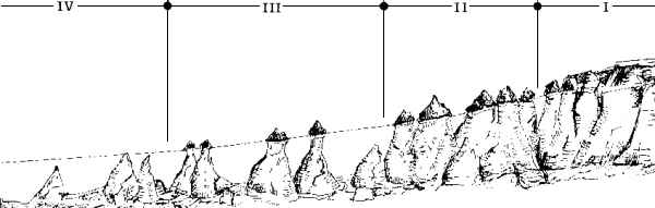
The erosional process in the region (Fig. 15) is a fairly recent one in terms of geological time, for the extreme variety of forms and the steepness of the slopes show that the landscape is still far short of the stage of complete levelling. The different patterns of erosional activity in the region point to a subdivision into zones in which it is possible to observe the development of a whole range of-forms (Göreme, Ürgüp, Çavuşin, Uçhisar), zones in which a single form is predominant (Ihlara) and zones with partial development of the forms (Selime, Derinkuyu, Soğanlı Dere). Of the zones in which it is possible to recognise the development of a whole range of features the most characteristic is the area along the slopes of the Kızılırmak valley. Here the main factors in erosion and the transport of eroded material are the scouring effects of the river and the lowering of its bed, these processes being promoted also by the natural slope of the valley. The rain-wash, channelled into an intricate network of pre-existing cracks and runnels, has formed a multitude of gullies. The carving out of these gullies would be a rapid process, promoted by the existing fissures in the rock, its permeability and brittle structure, and the continual removal of material by the strong hydraulic action of the river. The heads of almost all these gullies lie along the line of the road from Ürgüp to Nevşehir. The rapid erosional process has created deep incisions with steep and sinuous sides on which the modelling effect of aeolian action has already begun, producing the first examples of "bees' nest" erosion. |
|
 |
|
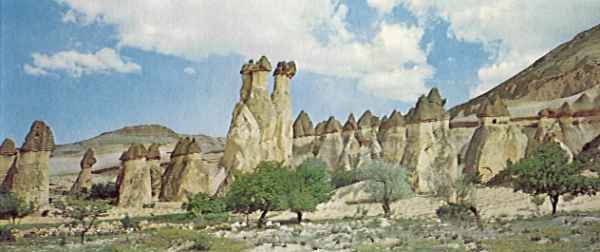
| Ph.
16: The "Monks' Valley" near Zelve. A landscape type midway between
the "groups of cones" and the "isolated cones", still in the intermediate
zone of the area of main drainage valleys. A zone of great erosional activity,
with rain-wash sapping the base of the rocks.
The long winding sides of these valleys have offered scope, in suitable places, for the hewing out by man of complex systems of dwellings, one on top of the other, occupying almost the whole of the rock face, as at Göreme, Ürgüp, Çavuşin and Uçhisar. Near the mouths of
the valleys, where the erosional processes have produced a fully graded
profile and sometimes a complete levelling, the rock faces lose their continuity
and give place to isolated residual pinnacles, the characteristic "fairy
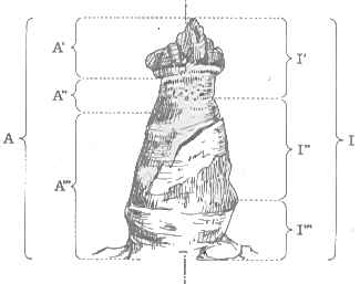
chimneys". These pinnacles are conical in shape, with rounded sides
rising at an angle usually greater than 60º, topped by a cap of harder
tufaceous rock which retards for a time the continuing process of mechanical
disintegration. The pre-existing cracks in the rock, usually running more
or less vertically, open the way to thermoclastic processes and rain-wash
which gradually carve out polygonal blocks of tuff with a bulk of several
cubic metres (Ph. 16, Fig. 16), the sides of which are then rounded
by aeolian action.
|
|
 |
|
Fig.
16: Morphological development of tufaceous series
The "canyon" of the Melendiz Suyu, near Ihlara, offers a different pattern of erosional activity in which the dominant morphological feature is a narrow valley with sub-vertical walls. This result is due partly to the characteristics of the catchment area of the river and partly to the hardness of the rock and the existence of a system of fractures running in the same direction. The river is continuing to cut ever deeper into the valley, seeking to reduce the difference in level between its drainage basin and the plain into which it emerges near Aksaray. The valley cuts through beds of reddish and brown tufaceous rock, the lower levels of which are fairly soft. This leads to undercutting and the collapse of large masses of rock, as can be observed near Ihlara. Throughout most of the region, however, the erosional processes have been able to operate only to a limited extent, producing morphological structures intermediate between the extremes represented by the valleys of the Kızılırmak and the Melendiz Suyu. As a rule these structures have no very marked distinctive characteristics: they may consist of small-scale features like those in the Derinkuyu area, or of a combination of a canyon-type valley with isolated residual pyramids as at Selime, or of relatively shallow erosion by scouring action, as at Soğanlı Dere. Since water is one of the principal agents in the development of land forms, this process will operate more rapidly in areas situated close to drainage basins, and will be slower in level areas where the only movement of water is that resulting from atmospheric precipitations. Future ProspectsIn the preceding pages we have considered the course of geological events, the salient morphological features of the region and the effects of erosion in changing, at varying rates and in varying degree, the pattern of the landscape. To these factors have been added, in historical times, the various activities of man, continually questing for places where he can live and supply his needs, cultivating the arid hillsides and hollowing out dwellings from the rock, and in the process sometimes achieving effects of considerable artistic quality.Although from the human point of view these activities represent a particular manifestation of the creative process, they are of purely negative effect from the geological or geomorphological point of view, serving merely to accelerate the processes of disintegration and erosion. And these processes have of course operated most intensively in the areas where the scale and density of human settlement is greatest. An effort to preserve the various forms and structures in their present aspect does not mean halting the development and transformation of the landscape; for this would merely lead to further distortions and in effect speed up the destructive action. The object should rather be, after careful study of the operation of these processes, both on a regional scale and in detail, to slow down the erosional action which can be observed at work. For any hydrogeological event, even one of catastrophic proportions, is merely the sum of a series of actions and reactions, which may escape the eye of the ordinary observer but nevertheless add up in the course of time to a major transformation. What is wanted, therefore, is a plan of action which takes account of the pattern of erosional activity, involving the proper regulation of the catchment area, with provision for the necessary drainage works and the stabilising of the valley sides. For the preservation of particular features (isolated pinnacles, towers, and so on) it will be necessary to work out the solution appropriate to the particular circumstances: this may involve, for example, repairing and consolidating the rock, sealing up cracks or fissures, using cramps to hold the structure together, and so on. It is important to realise the urgency of this restoration work. The processes of erosion are now operating at such a rate as to constitute a grave threat to this remarkable landscape which, as a result of the presence and the varied activities of man, has been in process of continual change and development since prehistoric times. |
|
|
|
|
|
|
|