Büyükkale, Acropolis of Hattusa
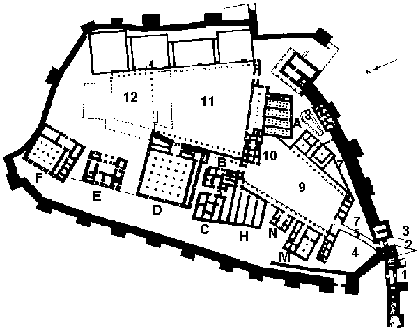
Büyükkale, Acropolis of Hattusa in the 14th and 13th centuries BC.
1) City Gate, built in the early Empire period (beginning of the 14th
century).
2) Acropolis Gate (13th century B. C.).
3) Postern, 34 m. long, built on the corbelling principle, with large
Cyclopean stone blocks (beginning of the 14th century).
4) Lower courtyard of the Acropolis.
5) Road paved with red marble slabs, stretching from the Acropolis Gate
to the South-West Hall (13th century B. C.).
6) South-West Hall, portico giving access to the acropolis (13th century
B. C.). The walls beneath the portico date from the early Empire period (beginning of the
14th century BC.).
7) Broad, well-paved road running parallel to the south fortifications on
the inside (13th century B. C.). This has been uncovered for a length of 40 m.
8) Basin, in which votive offerings were found; probably used for ritual
purposes (13th century BC.).
9) Middle Courtyard (13th century) surrounded by Buildings M, N, H, B,
10, A, G, 6. The courtyard seems to have played the role of an important square for public
and official meetings, and may be regarded as a kind of "State Agora".
A) Archives of the Hittite Empire (13th century). The oldest building in
history known to have been built as a library. The main structure is 32 m. long and
consists of store-rooms on the ground floor. In the four southern rooms, double rows of
rectangular limestone pillar bases have been uncovered, but some of these have since
disappeared. The pillars and the walls of the rooms shared the support of the first floor.
A staircase leading to this was probably installed in the easternmost and narrowest room,
in which no pillar bases have been found. Most of the 3,350 clay tablets inscribed with
cuneiform writing, which have been preserved either whole or in fragments, were found in
the three southern rooms. The tablets stood on end, like modern books, on wooden shelves
fitted along the walls. Labels were discovered, also in clay, indicating the contents of
the tablets, for instance, "Tablets concerning the deeds of Mursili" or
"Thirty-two tablets concerning the Purulli festival of the city of Nerik".
G) This structure, as the remains show, was embellished with limestone
and granite orthostats, as well as with mural paintings; therefore it can be considered
one of the most important buildings of the acropolis. (13th century B. C.).
M) Built in the 13th century B. C. and preceded by a pillared hall, this
building was probably reserved for administrative and official purposes.
N) From its tripartite ground plan, this building can be identified as a
monumental gateway of the 13th century. It is comparable with the gate-houses of the
temple of the Storm God at Hattusa (plan of temples)
and of the temple at Yazılıkaya (No. 150),
which follow similar schemes. It seems that the "processional. way" reached the
courtyard of the public and official buildings (9) through Gatehouse N. Actually the front
of the Citadel Gate is not oriented in the some direction as the entrance to the
South-West Hall (6) but rather overlooks the road skirting Buildings M, N, H, C, D, E and
F.
B, H) The function of these two buildings dating from
the 13th century is unknown.
C) This 13th century structure may be taken to have been a small shrine,
since jugs, plates, beakers, and shells, probably all votive offerings, were found in its
central room.
D) The largest structure on the acropolis so far unearthed. It dates from
the 13th century and measures 39 x 48 m. The ground floor was occupied by narrow,
rectangular rooms. As Rudolf Naumann suggests, the first floor probably comprised a
spacious audience hall with a wide view of the surrounding landscape, including the temple
of the Weather God of Hatti.
E) Building E, erected in the 13th century, was very probably a small
reception hall. With its almost symmetrical ground plan, this edifice is entirely
different from the other buildings at Hattusa and recalls the Bit Hilani type of building
first encountered in the plan of Niqmepa's palace (15th or 14th century) at Tell Açana
near Antakya.
F) Building F, constructed in the 13th century in the north-west corner
of the citadel, may be regarded as one of the private houses used by the royal family. Its
dominating and strategic position above the highway leading to the capital and the
magnificent view it commands in three directions must have made it a very suitable
residence for the Great Kings.
10) The Palace Gate, built in the 13th century B. C. displays the some
triple ground plan, with three rooms along each side, as observed in Building N. It gave
access to the upper courtyard in the palace area.
11) The palace buildings proper were situated in the highest part of the
acropolis.
12) The summit has been leveled off over a wide area. Holes in the rock
marking the positions of pillars are still visible.
The foundations and remains of walls belonging to structures built of roughly cut small
stones situated on the south and south-west slopes of the acropolis go back to the
Phrygian period. They date from the 7th and 6th centuries B. C. The narrow paved road
leading up for a stretch of 45 m., winding its way from a well at the foot of the
acropolis as far as the gate to the citadel in the south-west, is also a Phrygian
construction dating from the 7th century B. C.
|