The Oldest Map of the World
 DATE:
6200 B.C. DATE:
6200 B.C.
LOCATION: Museum at Konya, Turkey
The human activity of graphically translating one's perception of his world is now
generally recognized as a universally acquired skill and one that pre-dates virtually all
other forms of written communication. Set in this pre-literate context and subjected to
the ravages of time, the identification of any artifact as "the oldest map", in
any definitive sense, becomes an elusive task. Nevertheless, searching for the earliest
forms of cartography is a continuing effort of considerable interest and fascination.
These discoveries provide not only chronological benchmarks and information about
geographical features and perceptions thereof, but they also verify the ubiquitous nature
of mapping, help to elucidate cultural differences and influences, provide valuable data
for tracing conceptual evolution in graphic presentations, and enable examination of
relationships to more "contemporary primitive" mapping.
 As
such, there are a number of well-known early examples which appear in most standard
accounts of the history of cartography. The most familiar artifacts presented as "the
oldest extant cartographic efforts" are the Babylonian maps engraved on clay tablets.
These maps vary in scale, ranging from small-scale world conceptions to regional, local
and large-scale depictions, down to building and grounds plans. In detailed accounts of
these cartographic artifacts there are conflicting estimates concerning their antiquity,
content and significance. Dates quoted by "authorities" may vary by as much as
1,500 years and the interpretation of specific symbols, colors, geographic locations and
names on these artifacts often differ in interpretation from scholar to scholar. As
such, there are a number of well-known early examples which appear in most standard
accounts of the history of cartography. The most familiar artifacts presented as "the
oldest extant cartographic efforts" are the Babylonian maps engraved on clay tablets.
These maps vary in scale, ranging from small-scale world conceptions to regional, local
and large-scale depictions, down to building and grounds plans. In detailed accounts of
these cartographic artifacts there are conflicting estimates concerning their antiquity,
content and significance. Dates quoted by "authorities" may vary by as much as
1,500 years and the interpretation of specific symbols, colors, geographic locations and
names on these artifacts often differ in interpretation from scholar to scholar.
One such Babylonian clay tablet that has been generally accepted as "the earliest
known map" is the artifact unearthed in 1930 at the excavated ruined city of Ga-Sur
at Nuzi [Yorghan Tepe], near the towns of Harran and Kirkuk, 200 miles north of the site
of Babylon [present-day Iraq]. Small enough to fit in the palm of your hand (7.6 x 6.8
cm), most authorities place the the date of this map-tablet from the dynasty of Sargon of
Akkad (2,300-2,500 B.C.); although, again, there is the conflicting date offered by the
distinguished Leo Bagrow of the Agade Period (3,800 B.C.). The surface of the tablet is
inscribed with a map of a district bounded by two ranges of hills and bisected by a
water-course. This particular tablet is drawn with cuneiform characters and stylized
symbols impressed, or scratched, on the clay. Inscriptions identify some features and
places. In the center the area of a plot of land is specified as 354 iku [about 12
hectares], and its owner is named Azala. None of the names of other places can be
understood except the one in the bottom left comer. This is Mashkan-dur-ibla, a place
mentioned in the texts from Nuzi as Durubla. By the name, the map is identified as of a
region near present-day Yorghan Tepe (Ga-Sur at the time, the name Nuzia 1,000 years
later), although the exact location is still unknown. Whether the map shows a stream
running down a valley to join another, or running from that to divide in to three, and
whether they are rivers or canals, cannot be determined. The shaded area at the left side,
to or from which the channels run, was named, but the writing is illegible. Groups of
overlapping semicircles mark ranges of hills, a convention used by artists then and in
later times. The geographic content consists of the area of a river valley which may be
that of the Euphrates flowing through a three-lobed delta and into a lake or sea in the
northern part of Mesopotamia. Also shown on this tablet may be the tributary river the
Wadi-Harran, the Zargos Mountains in the east, the Lebanon, or Anti-Lebanon in the west,
and cities which are symbolized by circles. North, East and West are indicated by
inscribed circles, implying that maps were aligned in the cardinal directions then as they
are now. This tablet also illustrates the sexagesimal system of mathematical cartography
developed by the Babylonians and represents the earliest known example of a topographic
map.
However, while the Babylonian clay tablet map described here has been the generally
accepted "earliest known map", another contender might be the cartographic
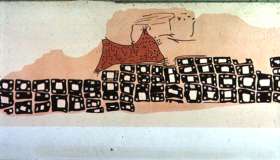
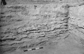
artifact found in 1963 by James Mellaart in Ankara, Turkey during an excavation of
Çatalhöyük in Anatolia. While less distinctive and on a much larger scale, this
unearthed map-form is a wall painting that is approximately nine feet long and has an in
situ radiocarbon date of 6,200 + 97 B.C. Mellaart believes that the map depicts a town
plan, matching Çatalhöyük itself, showing the congested "beehive" design of
the settlement and displaying a total of some 80 buildings. One illustration of this map
shows the painting from the north and east walls of the shrine. In the foreground is a
town arising in graded terraces closely packed with rectangular houses. Behind the town an
erupting volcano is illustrated, its sides covered with incandescent volcanic bombs
rolling down the slopes of the mountain. Others are thrown from the erupting cone above
which hovers a cloud of smoke and ashes. The twin cones of the volcano suggest that an
eruption of Hasan Dağ, rising to a height of 10.672 feet, and standing at the eastern end
of the Konya Plain and visible from Çatalhöyük, is recorded here. These local volcanic
mountains were important to the inhabitants of Çatalhöyük as a source of obsidian used
in the making of tools, weapons, jewelry, mirrors and other objects. Further, from graphic
embellishments around the mountain, Mellaart has speculated that the depiction of the
volcano in an active state is accurate since vulcanism in this area continued for some
4,000 years later.
Clearly, the Çatalhöyük "map" is still not the beginning of cartographic
history. Investigation into the earliest beginnings of cartography will continue with a
fair probability of further successes. This optimism is warranted by the fact the the
materials used during these periods to record such geographical spatial concepts were more
durable elements such as stone, clay, metal, earthenware, etc., unlike later cartographic
artifacts made of more fragile materials such as paper and wood.
|